Slider 1

Instrumented Bike+Share

Keep your safety on bike.
Slider 2

Updated on 5/9

Explore bumpy roads on your phones and watches.
Slider 3

Available Now!

We are a professional team.

Video

Welcome to the instrumented bike share world! Please play the video below to know more.

About

The objective of the capstone project is to develop instrumented bicycles that will be used to collect real-time information of infrastructure systems (corridors, bike roads, sidewalks, pedestrians, etc.), analyze field data, exam their quality, and provide recommendations to decision makers for improving the efficiency and ubiquitous use of bicycle mobility.

Flow Bikeman

On our campus and the surrounding roads, the degree of road damaging will be different every year. Traditionally, the department of transportation uses a huge detection car to detect road damage. Our client Dr. Ho finds that it was not only cumbersome, but also only applicable to motor vehicles, and it is expensive. Hence, the goal of our team is to finish the same function based on bikes. However, compared to the huge detection car, our devices have more advantages: it costs less, applies to any road, and is more portable.

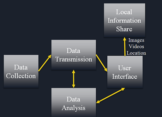
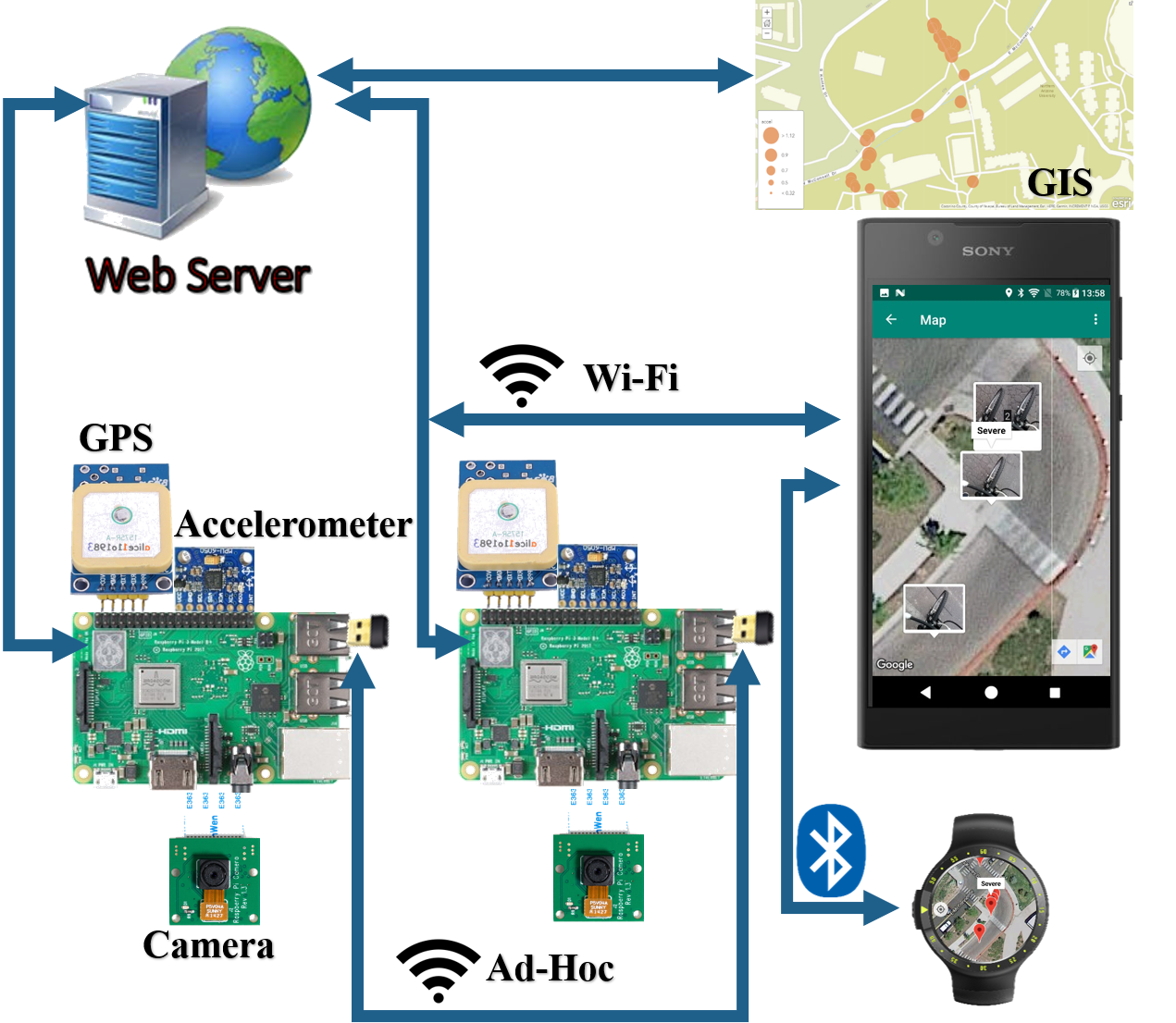
The basic components consist of a camera, an accelerometer, the Global Positioning System (GPS), the Android mobile application development, and data analysis. The accelerometers will save three-dimensional data, the camera will show real-time videos of the roads as a reference, and the GPS will record the location information of the bumps. As for the App, we determine to design one for the Android system with a humanized user interface.

In terms of the data sharing, we use Wi-Fi and wireless mesh network (WMN) to share the information with other users. Finally, our test routes mainly focus on bike lanes on campus, which helps us to amend our design scheme based on the results of each experiment.
Solution

A large battery ensures to use for more than 6 hours. A optimized app allows to enjoy smoothly at any time. Please tap or click pictures for more information.

Smiley face
App: Compatable with Android Phone 5.0.0 or higher and Android Watch 6.0.0 or higher.
Smiley face
MPU-6050 3 Axis Accelerometer.
Smiley face
NEO-7M GPS satellite positioning module.
Smiley face
TL-WN725N is used to build the Wi-Fi mesh network.
Smiley face
The GPS antenna is used to enhance GPS signals.
Smiley face
Microcontroller: Raspberry Pi 3B+ with onboard Wi-Fi module.
Smiley face
Raspberry Pi Camera module, 1080p.
Smiley face
22,000mAh portable solar charger.

Project Depiction

"Make it as simple as possible, but not simpler."

Albert Einstein

Description

Our main microcontroller is the Raspberry Pi, which is used to control all the data collection modules, including a GPS module, a camera and an accelerometer to get fluctuation information. The onboard Wi-Fi module is used to build mesh as well as calculate and analyze the pictures about the road information. We use the changes of the accelerometer to determine whether the road is flat and set up the threshold value manually to tell the roughness of the road. In addition, the GPS is used to locate the position of the bumps on the lanes and helps the users to mark on the mobile phone or watch.

The mobile system is used to share the pavement information, including the road condition with pictures or videos, and some marked bump points. What’s more, we use a camera settled on the bike frame to record the road as a reference for users, which can be uploaded on our phone and watch.

According to the information collected on the phone, the users can determine whether they need to change another road for travel. Our main focus is to combine the data acquisition and processing part of the Raspberry Pi system with the user-oriented part of the Android system.
Milestone

Here are the breakthroughs throughout the senior year.

November 2018

We completed the prototype with STM32 microcontroller. Please click the button below to download the presentation slides.

February 2019

We completed the data logging, data sharing and data processing tasks with Raspberry Pi. Please click the button below to download the design review 3 presentation slides.

March 2019

We completed the Android app design and did tests around NAU campus. Please click the button below to download the design review 4 presentation slides.

April 2019

We completed our capstone project and partipated in the UGRADS. Please click the button below to download the poster.

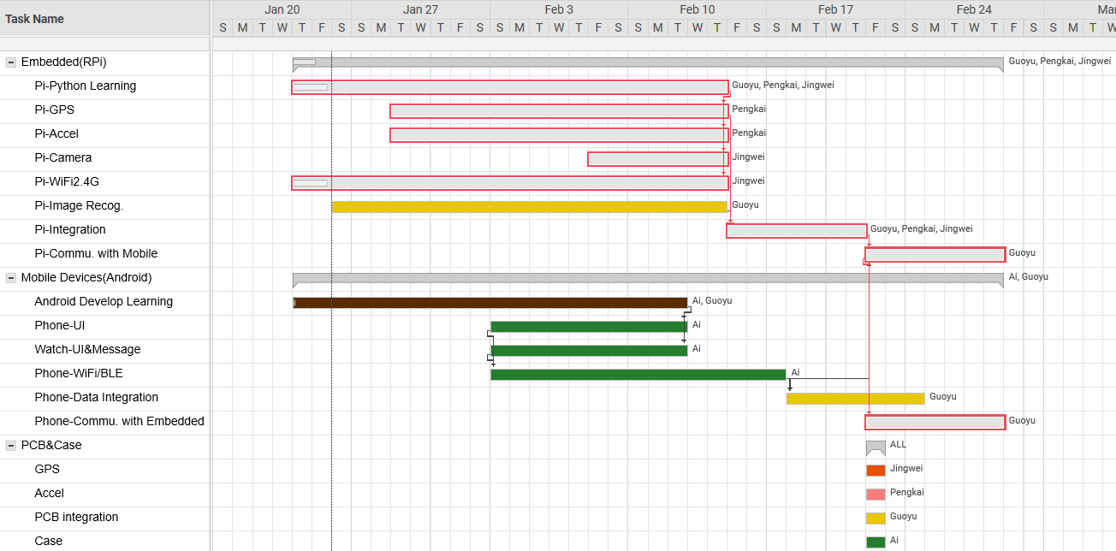
Work Breakdown Structure


Schedule


Description


Methods

We applied the technologies below and solved related problems successfully.

1. TensorFlow for speeding up float points calculation with deep learning on embedded systems.

Note: Regarding how to label images and what tools we should use, we have two choices, which are machine learning and image processing. They both require powerful calculation capability but the result of image processing is more likely to be influenced by shadows, so we finally chose the deep leaning technique.

2. Raspberry Pi 3B+ for collecting and sharing data.

Note: Originally we applied STM32 microcontroller as our processor, but it cannot run the deep learning algorithm so we changed it to Raspberry Pi in the spring semester.

3. Ad Hoc network for sharing data locally.

Note: To ensure that users can share data at any time and at any place, will build this mesh to allow users to check road conditions even without the Internet.

4. Transfer learning for neural network training.

Note: Since our dataset is small, we have to retrain an existing neural network.

5. Serial communication between the microcontroller and GPS.

Note: It is difficult to determine what sampling frequency the GPS should be, then we did a large number of tests using 1Hz, 5Hz, and 10Hz, but we found that the default 1Hz is the best because the GPS is less possible to get errors under that frequency, and another reason is that the running speed of the bike is slow so the system can sample enough data in unit time.

6. Python programming for machine learning.

7. Android programming for phone and watch APP.

8. IIC Communication between the microcontroller and accelerometer.

9. FTP for transferring files from the Raspberry Pi to the smartphone.

10. TCP for the phone controlling the Raspberry Pi.

11. Android programming for phone and watch APP.

12. GIS (Geographical Information System) for showing road conditions online.


Test

The figure below is from the ArcGIS. Blue points are moderately damaged roads and red points are severely damaged roads.

test


Team

We are a team of 4, who are from China, and we are part of the dual bachelor degree program of Northern Arizona University and Chongqing University of Posts and Telecommunications.

Mentors

We would like to thank Dr. Chun-Hsing Ho for his sponsor for our project and giving us the opportunity to improve our professional skills throughout this challenging project. Also, we thank Dr. Kyle Winfree for his technical help and directing us to the right way of the capstone project.

Kyle

Kyle Winfree

Electrical Engineering & P.h.D

Technical support.

kyle.winfree@nau.edu

.

Kyle

Chun-Hsing Ho

Civil Engineering & P.h.D

Sponsor and ideas provider.

chun-hsing.ho@nau.edu

.