
Project Introduction
The United States has one of the largest exclusive economic zones (EEZ) in the world.
An EEZ is an area of ocean where the owning territory has exclusive rights to the exploration
and resources of the area. The United States has 4,383,000 square miles of EEZ which means the
United States has 4,383,000 square miles of EEZ to patrol and protect. 4,383,000 square miles is
about 1.14 times larger than Canada and about 1.155 times larger than the United States. The United States Coast Guard (USCG)
is responsible for watching and protecting our coasts and this is a major job. Our client, General Dynamics Mission Systems (GDMS),
is responsible for working with the USCG on the Rescue21 system for assistance with search and rescue (SAR) missions.
Whenever there is a problem at sea and you need assistance the USCG is the one to pick up the call but how does the USCG
even begin searching the ~4.4 million square miles off our coast? The answer lies in the Rescue21 system which is a
system of antenna towers, called remote fixed facilities (RFF), that are placed strategically off our coasts with
directional finding very high frequency radios that are used to pick up distress signals, the direction of the signal,
the strength of the signal, and whether or not it is a hoax call. This information can be used to
dramatically reduce the area that needs to be searched saving time, money, and increasing the likelihood of those in distress being rescued.
Previous Project Progress
GDMS is content with the Rescue21 system however they want some additional features that will help them with maintaining their system. There are two main features that they need: the ability to record the power levels of the antennas at an RFF and the ability to record the weather information at the RFF sites. Knowing this information will help GDMS with determining the cause of RF interference. RF interference is what causes static while communicating over the VHF signal and it can be caused by a few different factors. One of those factors is that the radio equipment is broken and needs to be replaced. The other factor is rain. Rain is conductive so if there is rain in the air then the signal will be absorbed by the rain and the signal will fade over distance. Knowing the cause of RF interference will help GDMS determine if they need to send a technician to an RFF site or not. The other reason that the weather information is helpful is when predicting damage. Knowing if there is a severe storm at an RFF site will help GDMS with predicting equipment outages before they happen so they can have someone ready to fix the site before an outage happens. This will help reduce outage times ensuring that the USCG can always do their job. Knowing the weather also helps with scheduling maintenance on a RFF site. GDMS doesn’t want to send someone to climb the antenna towers in the middle of high winds or storms. Knowing the weather will help GDMS by reducing the amount of times they send a technician to a site when they cannot perform maintenance.
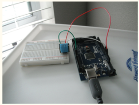
GDMS contacted NAU in order to build the device that
would record the antenna power and weather data last year. The project went very well as they were able to build a
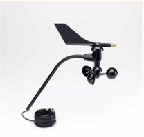
site weather and power recorder (SWAPR) which worked just as expected. Below are images of the Humidity Sensor and a
Wind Sensor from last year's SWAPR device.
The only shortcomings to the SWAPR device was that the data being given out is not human readable. That is why GDMS reached out to NAU again this year to build the software for the SWAPR network. GDMS is looking to have the data be displayed in a human readable way on a secure website.
Our Project Problem
We are trying to solve the problem with the SWAPR device which is that it only collects the power and weather data from an RFF site but it doesn’t do anything to make the output human readable. Currently a SWAPR device will output the antenna power and weather data in a list of numbers like [-124, -92, -87, -95, 64, 78.0, 1012, 3.2, 43] where the numbers represent [frequency one power (dBm), frequency two power, frequency three power, frequency four power, humidity (%), temperature (F), wind speed (mph), wind direction (degrees)]. There is a print out every five seconds and there are almost 260 RFF that would have one of these devices. As you can see that is a lot of information to go through as a human and make sense of. That is why we are building a secure website that will collect, store, analyze, and build and display a couple of different views that can very quickly be used by GDMS to make decisions that save them time and money.
- SWAPR device output is unreadable to humans
- [-123, -92, -87, -85, 64, 78.0, 1012, 3.2, 43]
- SWAPR device output is hard to analyze by humans
- The first value of -123 is telling us that there is a potential problem with the first frequency because -123 is not in the range of acceptable values. However, the other three frequencies (-92, -87, -85) are all working as they should since they are in the range of acceptable values.
- There is a large amount of SWAPR data
- SWAPR devices give out data every five seconds
- Over 260 required in the system
- The data needs to be easily accessible
- SWAPR devices do not store any data
- If SWAPR data is stored it is only stored on the device
- SWAPR devices are very simple and cannot send their data
- SWAPR devices are built to only record information and have no way of sending or analyzing data
- SWAPR data needs to remain secure meaning it needs to be stored and accessed in a secure environment
- As the SWAPR data is only on the device, it is not being stored or accessed
The initial project proposal for this project was provided by our sponsor, General Dynamics.
Competitive Products and/or related solutions
There are no other products and/or related solutions that we know of. This is because our client works closely with United States Government which means we are not privileged to most of our clients workflow unless it is public information.