Project Description
The project focuses on a segment of JWP Blvd. situated between two key
intersections. JWP originates at the Interstate 17 (I-17) off-ramp and extends
approximately 4 miles eastward. Specifically, this project centers on the
1.5-mile section between South Pulliam Dr. and Lake Mary Rd., traversing a
region characterized by dense forests and challenging terrain.
The project is located in the west portion of Flagstaff, Arizona. The project site lies south of where the I-17 and I-40 intersect and north of Flagstaff Pulliam Airport.
Project Vicinity Map

Project Location Map
Back to Top
This project faces several constraints. Firstly, the road's route must circumvent a VHF (Very High Frequency Omnidirectional) device to avoid interference with operations at Flagstaff Pulliam Airport. While the specific path of the road can be adjusted, the starting and ending points remain fixed due to predetermined intersection requirements. Additionally, Flagstaff is prone to severe weather conditions, particularly during winter, which poses a challenge by potentially hindering or slowing down the progress of the project.
Back to Top
-
1.1 Research and Data Collection - Research
local, state, and federal regulations that will guide the project.
-
1.2 Identify Design Vehicle - Identify
the types of vehicles that will utilize the proposed roadway and analyze
vehicles that currently use alternative routes.
-
1.3 Collect Existing Geotechnical Data - Extract
USDA Web Soil Survey (WSS) to access soil information, maps, and reports that
pertains to the project site.
-
2.1 Site Visit Planning - Create
a field safety checklist, outline activities to complete during the site visit,
and identify equipment/tools to be used.
-
2.2 Land Survey - Conduct
a land survey to measure and document conditions of the project site.
-
2.3 Traffic Counts - Collect
raw data directly from the project site’s intersections to assess the level of
service.
-
2.4 Photographs of Existing Site - Take
photos of the existing intersections at each end of the corridor and along the
proposed road alignment.
-
2.5 Collect Existing Hydraulic Structure Data - Obtain
data and conditions of the current hydraulic structures in the project site.
-
2.6 Geotech Analysis - Analyze geotechnical
information to assess the soil conditions of the project site.
-
2.7 Topographic Map - Process
existing topographical data from the City of Flagstaff using engineering
software.
-
3.1 Watershed Delineation - Identify
boundaries of watersheds within the project site
-
3.2 Time of Concentration - Calculate
the time of concentration for stormwater runoff.
-
3.3 Storm Intensity - Determine storm
intensity of site.
-
3.4 Calculate Peak Flow - Evaluate
stormwater runoff using hydrological modeling software and the Rational Method.
-
4.1 Existing Culvert Analysis -
Examine
current culvert systems within the project site through evaluating its maximum
capacity and velocities of the structures, as well its performance under
various flow conditions.
-
4.2 Existing Channel Analysis - Examine
current channels within the project site through assessing the channel
geometry, flow velocities, sediment transport, and the determination of max
capacity and velocities.
-
4.3 Post-Improvement Hydrologic Analysis - Determine
the new peak flow that the hydraulic structures will need to carry.
-
4.4 Proposed Culvert and Channel Design - Develop
alternatives for culverts and channels within the project site to ensure
efficient water management, prevent flooding, and meet regulatory standards.
- 4.4.1 Determine Criteria - Establish
requirements that the proposed culvert and channel design must meet.
- 4.4.2 Develop Alternatives - Develop
various design alternatives for the culvert and channel improvements.
- 4.4.3 Analyze Alternatives and Select Best - Analyze alternatives and use a decision matrix to determine the best.
-
5.1 Roadway Geometry - Establish
the geometry for the proposed roadway. The geometry design elements include
lane widths, shoulder widths, bike lanes, and clear zones.
-
5.2 Intersection Design - Select
appropriate intersection type for the proposed road.
-
5.2.1 Determine Criteria
-
5.2.2 Develop Alternatives
-
5.2.3 Analyze Alternatives and Select Best
-
5.3 Pavement Design - Determine
a pavement design for the proposed roadway.
-
5.3.1 Determine Criteria
-
5.3.2 Develop Alternatives
-
5.3.3 Analyze Alternatives and Select Best
-
5.4 Sidewalk Design - Design
a safe and efficient sidewalk for pedestrians.
-
5.5 Signage and Striping - Identify
appropriate signage and striping in accordance with established standards.
-
6.1 Cover Sheet - Provides
an overview of the entire set of construction plans, including project title,
location, key contacts, and general project description.
-
6.2 Existing Site Plan - Presents
the current conditions of the project site, including topography, vegetation,
and surrounding infrastructure.
-
6.3 Plans and Profiles - Develop
detailed drawings of the roadway, including alignments, cross sections, and
profiles, for construction guidance and earthwork calculations.
-
6.4 Details Sheets - Create
design details for roadway elements, such as pavements, drainage systems,
signage, and traffic control devices.
-
7.1 Construction Cost - Calculate
excavation, additional materials (subbase, subgrade, etc.), labor, equipment,
and other project-specific expenses.
-
7.2 Operation and Maintenance Cost - Evaluate
expected lifespan of roadway and maintenance/operational costs.
-
Evaluate
social, environmental, and economic impacts.
-
9.1 30% Submittal - The
submission for this milestone will include the Design Report, Presentation, and
Construction Drawings (cover sheet and site plan). It will encompass completed
tasks related to research and data collection, site investigation, and
hydrologic analysis.
-
9.2 60% Submittal - This
milestone's submission will consist of the Design Report, Presentation, and
Construction Drawings (plans and profiles). It will encompass completed tasks
related to hydraulic analysis and roadway design.
-
9.3 90% Submittal - The
submission for this milestone will include the Design Report, Draft
Presentation, Draft Website, and Construction Drawings (details sheet). It will
encompass completed tasks related to construction plans, economic analysis, and
impacts analysis.
-
9.4 Final Submittal - Submission
will include the complete Design Report, Presentation, Website and Construction
Drawings.
-
10.1 Meetings - Meetings
will be conducted on a weekly basis to discuss current project progress and to
deliberate on project tasks that require attention.
-
10.2 Schedule Management - The
schedule will be maintained and updated to ensure project is completed on time.
-
10.3 Resource Mangement - Staff and resources
will be managed to ensure project is completed on budget.
- The following items will not be included nor
collected for the project, due to the amount of time allotted for this project;
considerations such as geotechnical lab sampling/testing and utilities
(sanitary sewer, water, storm, gas, electrical, etc.) will not be included in
the final design. While the Flagstaff Urban Trail System (FUTS) will also not
be included into the design process, it will be considered for further later
development.
Back to Top
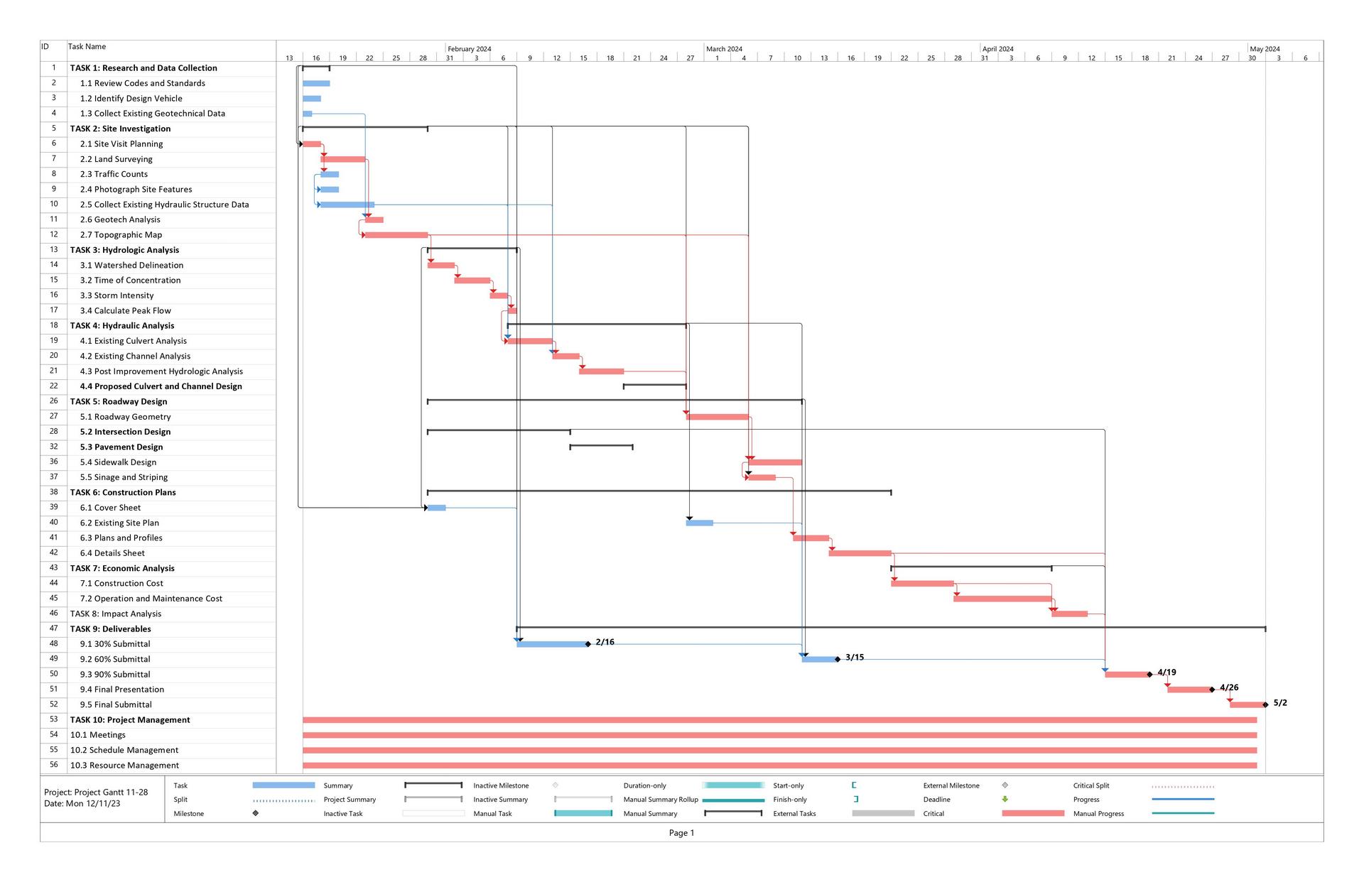
The Gantt chart below depicts the projects schedule. The project is scheduled to commence on January 16,
2024 with a total task duration of 73 days, excluding weekends. Task 1:
Research and Data Collection, Task 2: Site Investigation, and Task 3:
Hydrologic Analysis, are planned for completion by February 16, 2024, reaching
the 30% submittal milestone. Task 4: Hydraulic Analysis and Task 5: Roadway
Design are targeted for completion by March 15, 2024, marking the 60% submittal
milestone. Task 6: Construction Plans, Task 7: Economic Analysis, and Task 8:
Impact Analysis are expected to be finished by April 19, 2024, reaching the 90%
submittal milestone. The final presentation will need to be prepared by April
26, 2024, and will encompass the entirety of the project. The final submittal
is slated for May 2, 2024, containing a fully detailed report.
 Back to Top
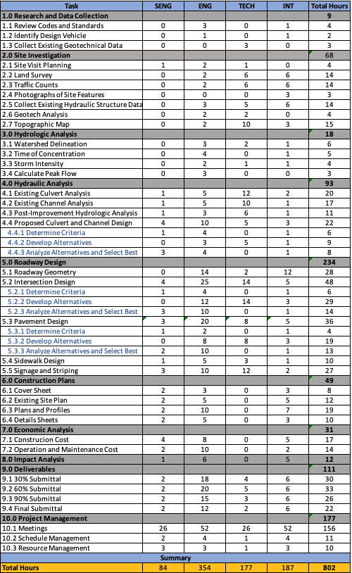
The
staffing plan provides an overview of the required personnel for the execution
of engineering services. All staffing requirements and time allocations are
calculated and assigned according to each staff member's respective
qualifications and overall contribution to the project’s completion.
 Back to Top
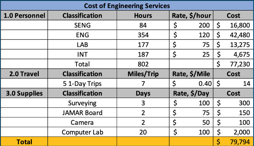
Cost of Engineering Services
The cost of engineering services is the
management of project cost, involving estimating, cost control, cost
forecasting, investment, and risk analysis.

Back to Top


 Back to Top
 Back to Top
