Scope of Services
TASK 1 RESERCH
To research topics that will help in the development of the Shadow Mountain drainage design project.
TASK 1.1 DOCUMENTS OF EXISTINGSTRUCTURES/GIS
Research topographic and GIS maps made available for public view of Shadow Mountain to establish the project boundaries.
TASK 1.2 RESEARCHRETENTINO/DETENTION OPTIONS
Research different types of basins, which include a dry and wet detention pond that can be referred to as a retention pond. Both are good for the protection against flooding.
TASK 1.3 FEMA FLOODPLAININFORMATION
The Federal Emergency Management Agency(FEMA’s) Regulatory Floodway data will be reviewed in connection with the project area.
TASK 1.4 IDENTIFY DESIGNREQUIREMENTS FOR FLAGSTAFF
Research criteria described in the City of Flagstaff Stormwater Management Design Manual and the Drainage Design Criteria Manual of the Coconino County.
TASK 1.5 REVIEW EXISTINGPLANS/STUDIES
Research the flood hazard map provided by the City of Flagstaff that will be used to look at for this project area identifying peak discharges and max depth.
TASK 1.6 CREATE A PLAN FOR THEFIELD SITE INVESTIGATION
Create a site investigation plan shall to determine the desired survey locations that would be relevant in cross-sectional data and/or informational for the project.
TASK 2 FIELD SITE INVESTIGATION
To conduct a thorough analysis of the Shadow Mountain area, the site will be evaluated with a field visit to the boundary points of the project area.
TASK 2.1 FIELD SITE VISIT
Conduct a field site visit to the Shadow Mountain Cul De Sac and the land north of the project site located on the Unisource property. Photos will be taken to document the current conditions, observing drainage runoff pathways, and existing stormwater drains.
TASK 2.2 FIELD SITE ASSESSMENT
Information collected during the site visit will be used to analyze the current condition of the Shadow Mountain area such as the runoff characteristics, and land use, land use cover, and determine the area of land above the Cul de sac that will be used to create the detention/retention basin.
TASK 3 HYDROLOGIC ANALYSIS
Historical precipitation data for the Shadow Mountain area will be used to create models that delineate the Spruce Ave. Watershed and analyzed the natural runoff flow characteristics such. This analysis will be done for a 100-year storm with a 24-hour rainfall, per the SCS Type 2 Rainfall Distribution requested in the City of Flagstaff Stormwater Design Manual.
TASK 3.1 WATERSHED DELINEATION
Use topographic maps and preexisting precipitation data to delineate the Spruce Ave. Watershed to determine the watershed area, the location of the point of concentration, the ultimate time of concentration, the rate of flow, existing sub-basin storage, design storm intensities, and the peak runoff flow in the Shadow Mountain area.
TASK 3. 2 DETERMINE TIME OFCONCENTRATION
To predict the volume of runoff that flows out of the Spruce Ave. Wash during a given storm event. The time of concentration will be determined by using data from the watershed delineation and topographic maps. Data calculated through this process will help determine the flow that needs to be designed for based on the Coconino County Stormwater Design Codes.
TASK 3.3 DETERMINE WATERSHEDROUGHNESS COEFFICIENT
Surface characteristics of the Spruce Ave. Watershed will be considered to accurately predict the rates of runoff flow. The roughness coefficients (C) change based on the roughness of the surface. The watershed will be broken up into different sub-basin areas to calculate the types of surfaces that occupy the entire watershed.
TASK 3.4 DETERMINE DESIGN STORMINTENSITIES
To determine the design storm intensities, the time of concentration, the NOAA Atlas 14, and design storm frequencies specified by the City of Flagstaff will be used. The depth of precipitation will represent the amount of rainfall from a storm event while the intensity of precipitation will represent the ratio of rainfall depth over a given time period.
TASK 3.5 DETERMINE NATURAL RUNOFF
The peak runoff flow in the Spruce Ave. Wash will be calculated using the areas of the sub-basins, runoff coefficients, and historical precipitation data.
TASK 3.6 ANALYZING EXISTINGSUB-BASIN STORAGE
Analyze the existing impacts of pre-existing retention and detention basins in the Spruce Ave. Watershed to find the volume of water that is currently accounted for.
TASK 4 HYDRAULIC ANALYSIS OF EXISTING STRUCTURES
Assess the current stormwater infrastructure at Shadow Mountain through existing GIS data or refer to notes from the site visit to get a better understanding of the current conditions. The capacity of existing structures will be determined.
TASK 5 ANALYSIS OF ALTERNATIVES
The design process consists of determining what to design, what standards to design to, and comparing multiple design possibilities against each other to determine the best solution.
TASK 5.1 DETERMINE CONSTRAINTS ANDCRITERIA OF DESIGN
The constraints will be determined by the physical capacity of the project site such as saturation capacity of soil, area of land available to build on, annual rainfall, time of construction, and budget. Criteria will be identified for the use of a systematic evaluations of alternative designs.
TASK 5.2 DEVELOP ALTERNATIVEDESIGNS TO REDUCE RUNOFF
Detention and retention basins require certain conditions to be effectively implemented. Characteristics such as an available area, existing surfaces, cost, and water quality requirements are all important considerations in determining which hydraulic structure will be the best option for the existing conditions. The pros and cons of a retention and detention basins will be analyzed to determine which structure will be best for the Shadow Mountain area. Another alternative could be a low impact development site design that uses natural and engineered infiltration to control storm water where it is generated, achieving a sustainable site design. The Maricopa Association of Governments (MAG) will be used to design structures.
TASK 5.3 SELECT BEST ALTERNATIVE
A decision matrix will be used to determine which design option(s) from the list of design alternatives is the best choice for the Shadow Mountain area.
TASK 6 FINAL DESIGN
Based on the detention/retention basin, and the low impact development site analysis, the proposed drainage design will be modified to represent the detention/retention basin determined as the best fit for the Shadow Mountain area. HEC-RAS will be used to find effective solutions for the storm events required by the Coconino County Drainage Design Manual. This will show where problems arise and how this can be improved to ultimately determine the solution used for the Shadow Mountain area.
TASK 7 CONSTRUCTION PLANS
The construction plans will be created for decreasing the velocity of the runoff flow on Mt Elden to this area and a detention/retention basin. The plans will provide guidance on how to construct and include specific details to help clarify plan details. The construction plan set will include the following pages: cover page, existing topography/site, proposed topography, plan, and profile cross sections of the hydraulic structure.
TASK 7.1 EXISTING FLOODPLAIN MAP
A map of the existing floodplain will be created to identify the areas within Shadow Mountain that are most impacted by flooding. The map will describe the behavior of flooding in the area and show where it mainly drains to and the average depth of flooding based on the 2-yr,10-yr, 25-yr, and 100-yr flooding required for design.
TASK 7.2 DESIGN OF RUNOFF CONTROLSTRUCTURE SHEETS
The design of runoff control structures will exist on the downhill slope of Mt. Elden that directly impacts the Shadow Mountain community. The types of sheets needed will be a complete plan of the runoff control structure. This control structure will help protect Mt. Elden and the community from erosion as well.
TASK 7.3 GENERAL PROJECT DETAILS
The details will be obtained from ADOT and Coconino County drainage design manuals. These details will be used to show the design of structures included in the design of the runoff control structures selected.
TASK 7.4 PROJECT NOTES ANDSPECIFICATONS
Any modifications of design changes made to original plans for the runoff control structure or detention/retention basin will be noted in this section of the construction plans.
TASK 8 CONSTRUCTION COST ESTIMATE
A budge for the cost of construction will be developed and included in the final report.
TASK 9 PROJECT IMPACTS EVALUATION
The stormwater drainage design chosen for the Shadow Mountain area will be evaluated for its social, economical, and environmental impacts.
TASK10 PROJECT DELIVERABLES
This task will detail what is included in each submittal and the sub-task associated with completing each listed task.
TASK 10.1 30% SUBMITTAL
This submittal is the initial products of the design process. At this time, tasks 1-3.4 will be completed. The deliverables required are the 30% draft of the final design report, a 30% construction plan set, and a presentation of the team’s progress. The final design report will have completed sections written of the project research, background information, site investigation visit, the site investigation assessment, and the initial hydrologic analysis of the watershed delineation. The 30% construction plan set will include the completed design plan minus annotations and details, a cover sheet, a vicinity map, and sheets cut for abbreviations, details, and cost estimate. The progress presentation will summarize all the information required above and a review of the construction plans.
TASK 10.2 60% SUBMITTAL
This submittal is a progress check that will begin work from where the 30% left off. It will address all comments made on the 30% to the report and construction plans. At this time, tasks 3.5-5 will be completed. The deliverables included are 60% of the final design report, a 60% construction plan set, and a presentation of the team’s progress. The final design report will have completed sections from the 30% submittal with the review comments addressed and include a completed written section for hydrological analysis, hydraulic analysis of existing structures and the completed design process written. The60% construction plan set will include a completed title page, completed vicinity map, completed details sheet, draft cost estimate sheet, annotated and complete design, all sheets required for a complete plan set cut and accurate title blocks on all sheets. The progress presentation will summarize all the information required above and a review of the construction plans.
TASK 10.3 90% SUBMITTAL
This is a submittal of all the team’s final work. At this time, tasks 6-9 will be completed. The deliverables required are the complete final report, a progress presentation, 90% construction plan set and website draft. The 90% construction plan set will include a title sheet, table of contents sheet, vicinity map, abbreviations sheet, general notes sheet, and completed design sheets for the detention/retention basin and runoff control structure. All comments made from the 60% submittal will be addressed. A draft of the project team’s website including all reports, presentations, and important information pertaining to the site and project deliverables. The progress presentation will summarize all the information required above and a review of the final construction plans. This presentation will focus on showing the project site’s proposed design versus its existing design.
TASK 10.4 FINAL SUBMITTAL
This will be the last submittal of all work with all comments addressed from the 90% review. At this time, task 10 will be completed the deliverables required are the complete final report, final construction plans, final website ready for publishing, and a final presentation. The final report, final construction plans, final website will have all previous comments addressed. The final presentation will contain all the information from previous presentations. This report will be given to a panel of practicing engineers from the Flagstaff community, client, GI and TA for grading and questions.
TASK 11 PROJECT MANAGEMENT
Project management will include meetings, scheduling, and resource management.
TASK 11.1 PROJECT MEETINGS
Throughout the duration of the project meetings will be held with the grading instructor (GI),technical advisor (TA), client, and the team. The purpose of the meetings is to make sure the project is progressing in the direction that it was intended. Each of these meetings allow an opportunity to discuss how to progress, clarify questions, receive a review of work and comments to make corrections.
TASK 11.2 SCHEDULE MANAGEMENT
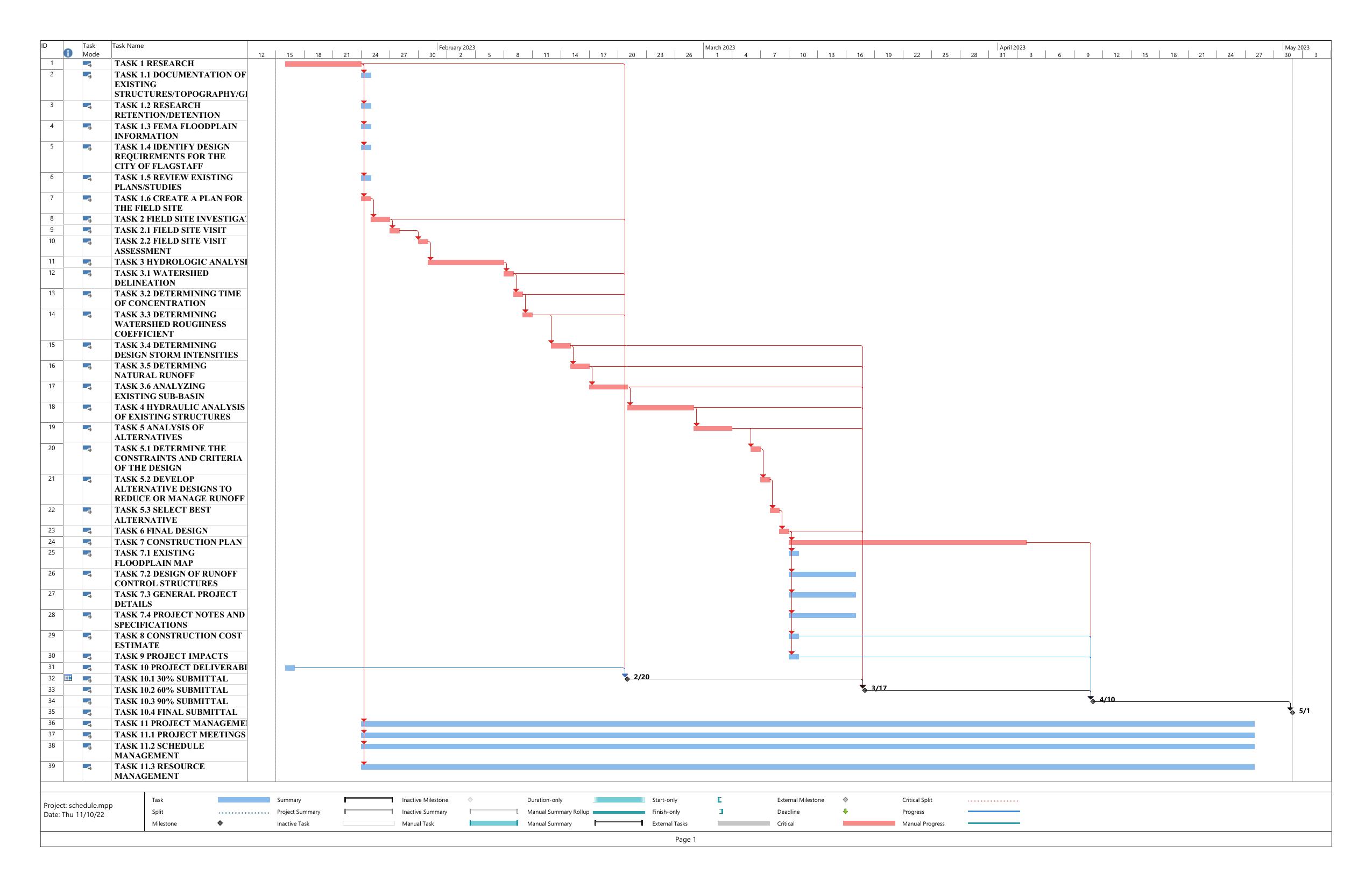
The schedule will be tracked and updated to reflect the team’s progress and ensure critical tasks are completed on time. Adjustments will be made to ensure all work is completed by the due date of the final submittals.
TASK 11.3 RESOURCE MANAGEMENT
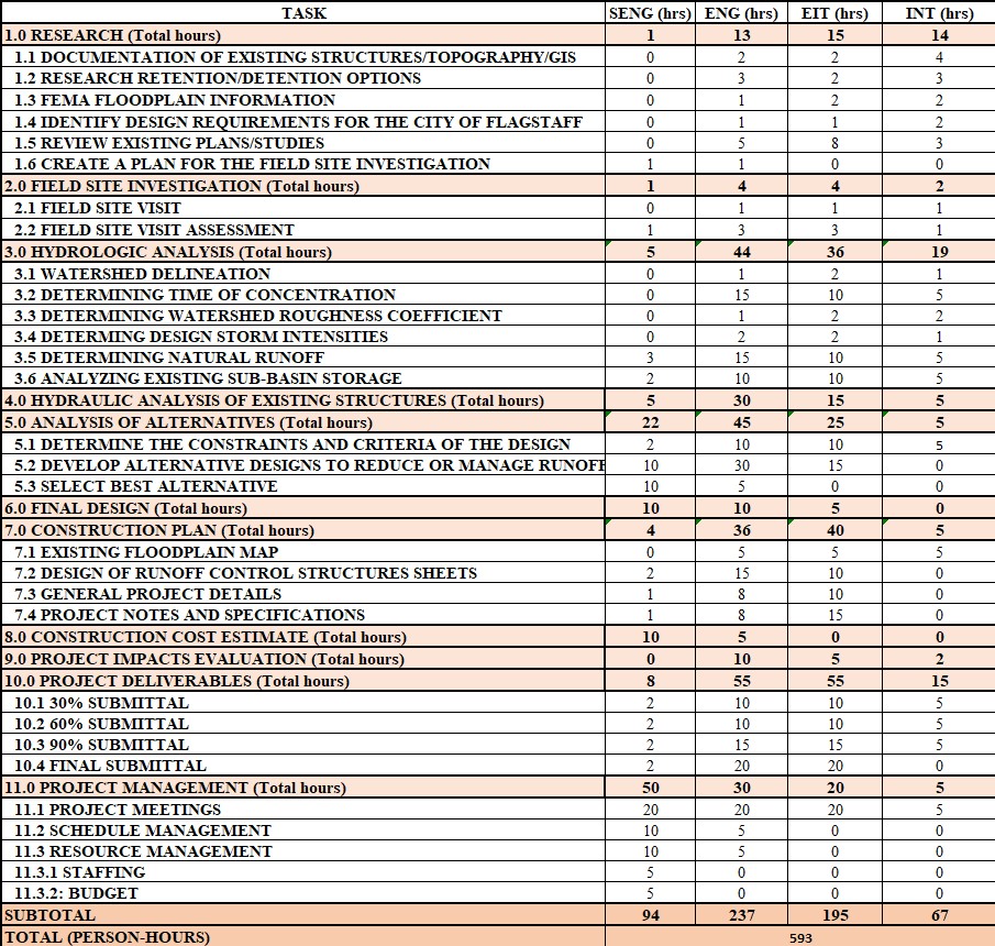
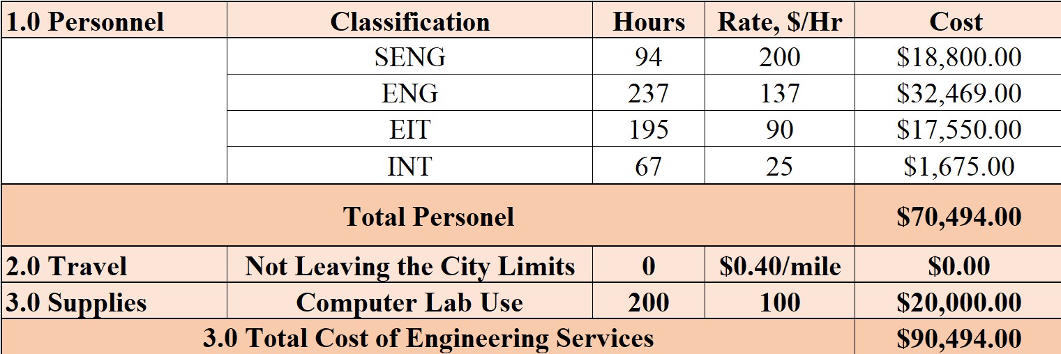
This will consist of tracking staffing and budget throughout the duration of the project. Staffing will track the number of hours each member of the team is spending on a given task to estimate the cost for engineering services throughout the project. The expenses of the project will be tracked and compared to the cost of engineering services to ensure the project is within budget.


