The Cinder Lake Landfill currently has limited knowledge of the movement
of leachate through the unsaturated zone under the landfill. There is potential
for leachate to pass through the unsaturated zone and contaminate the Coconino Aquifer
1600 feet below the landfill surface. The project will utilize 1 and 3-dimensional modeling
to determine how long it will take leachate to reach the underlying aquifer after landfill closure.
The main constraints to the project is lack of data and necessary assumptions. The soil layers
underlying the aquifer are complex and not consistent throughout the landfill, so the soil and rock
layers were assumed to be uniform across the entire area fo the landfill. The 3-dimensional model
requires geotechnical and soil input data that is not available.
The Hydraulic Evaluation for Landfill Performance (HELP) model, a 1-dimensional landfill leachate flow model, was ran to determine the percolation rate of leachate exiting the bottom of the landfill into the unsaturated zone after landfill closure in 2060. The percolation rate is 2.48 inches per year. The flow rate of leachate was 971,410 cubic feet per year over the 108 acre landfill area. The percolation rate and flow rate found using HELP was used as the input flow for 3-D modeling.
The complex lithology of the unsaturated zone required simplifation for further modeling. The soil and rock layers were simplified into 6 layers: cinders, upper basalt, conglomeate soil, lower basalt, limestone, and sandstone.
The decision matrix below shows 3 different softwares and their associated graphical user interface analyzed for further modeling. The criteria used to evaluate each option was cost, user interface complexity, and graphical output capability, which were all weighted equally and scored 1-10 with 10 being the best score. SUTRA/ModelMuse and MODFLOW-NWT/ModelMuse both scored the highest because they are both free while TOUGH2/PetraSim was $1,200. All modeling softwares were complex due to the team having no prior flow modeling experience, but SUTRA/ModelMuse scored the lowest due to its limited availability of tutorials to help the team learn the software in comparison to the other 2 options. MODFLOW-NWT/ModelMuse scored the lowest in graphical output capability because it only provided 2-dimensional results while the other two options were able to provide 3-dimensional results. SUTRA/ModelMuse scored the highest, so it was selected as the best option for further modeling.
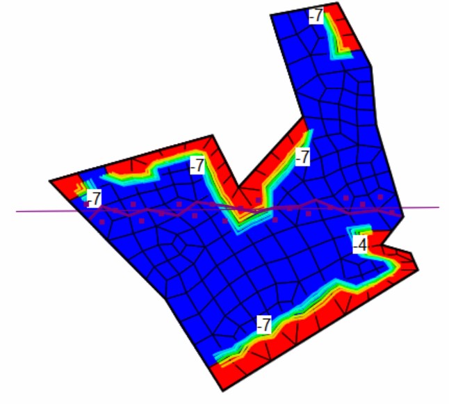
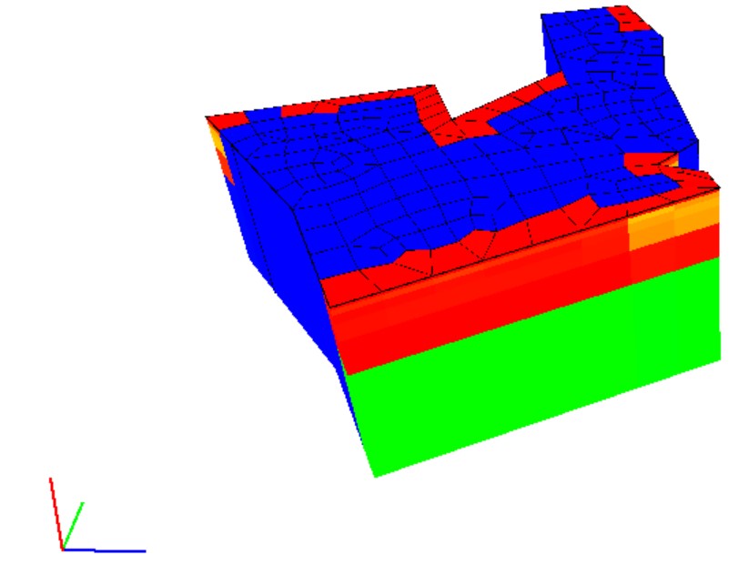
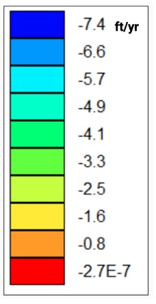
The color legend shows the vertical flow velocity downward through the unsaturated zone. The top view of the modeling results show that most of the flow velocity is 7.4 ft/yr shown in blue with a decreasing vertical flow velocity gradient towards portions of the landfill boundaries shown in red. The 3-D view depicts the landfill footprint throughout the entire unsaturated zone directly under the landfill. When leachate has the highest flow velocity of 7.4 ft/yr, it will take 217 years to reach the underlying aquifer. Therefore the landfill should not be immediately concerned about groundwater contamination because it is unlikely that leachate will reach the aquifer in the near future. However, many inputs had to be assumed due to lack of available data. Therefore, further data collection is necessary to create a model that more accurately represents the landfill.


created with
Website Builder Software .