About the Project
Facilitating Forest Monitoring with Mobile Lidar
Check out the sponsor's project info.
Facilitating Forest Monitoring with Mobile Lidar
Check out the sponsor's project info.
Forest ecosystem health is at the center of many large-scale environmental problems that we face today.
Efforts to prevent wildfires and handle their fallout, for example, or to ensure that forests maintain their important
role as carbon sinks while climate change progresses, will benefit from an increased understanding of these crucial environments.
Mobile lidar scanning, a technique that relies on lidar, a remote sensing technology, is used to gather large amounts
of three-dimensional data from forests. These data can in theory be used to create visual models or answer quantitative
questions about forest makeup. In practice, it is difficult for the non-specialist to make much sense of the vast and
complicated data that result. Tools exist to help with stages of the pipeline, but many require technical knowledge or
were developed for airborne lidar scanning, a separate technology.
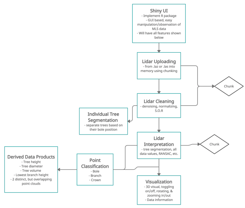
To bridge this gap, we plan to develop a start-to-end solution that is accessible by the non-specialist, and delivers
results in the browser. The solution will accept mobile lidar data as input, and generate various useful statistics and
visualizations which can be filtered and manipulated within a web application. This will improve upon the currently used methods,
which are somewhat strung together and lack a cohesive pipeline.
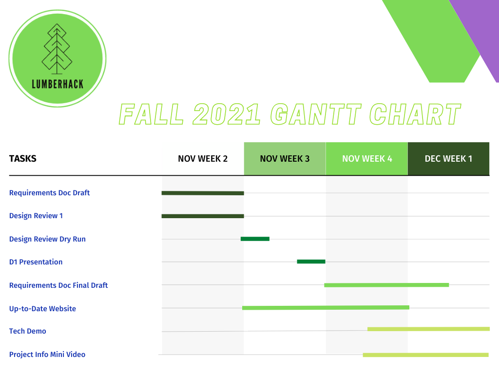
Requirements have been gathered through multiple meetings with our client with discussions on what already exists, and what should exist.
The Requirements Specification Document is linked on the Deliverables page.
These requirements are split into three sections:
Functional
The envisioned solution of this project will serve as a resource for researchers and ecologists to analyze their own MLS data. As part of the final product, the team plans to create an easy-to-use application with the following features:
The technologies used in the software development for our project are:
GitHub: The ability to work collaboratively on code allows all team members to develop portions of the code that can be integrated without issues.
R: With R's ability to effectively manage data by reshaping, cleaning and analyzing it is a key technology to be used in the management of the point cloud data generated from mobile lidar systems.
C++: Using multithreaded operations data can be efficiently loaded and used, which will improve the performance of our project. C++ also offer's tools that can provide 3d visualizations of the mobile lidar point cloud data.