Project Area in Flagstaff, Arizona.
Project Area in Flagstaff, Arizona.
Western Terminus of Project
Eastern Terminus of Project
Task 1.0: Obtain Existing Data
Existing data will be obtained before any assessment or analysis to better understand the existing conditions and to obtain a good understanding of the project from a data perspective
Task 1.1: Topo/GIS Data
Task 1.2: Land Ownership Data
Task 1.3: Geotechnical Data
Task 1.4: Traffic Projections
Task 6.0: Final Hydrologic and Hydraulic Analyses
This task considers design of required hydraulic structures for the roadway.
Task 6.1: Selection of Hydraulic Structures for Water Crossings
Task 6.2: Design of Hydraulic Structures for Water Crossings
Task 6.3: Final Hydrologic and Hydraulic Analyses
Task 7.0: Plan Set Development and Cost Estimate
This task considers design of required hydraulic structures for the roadway.
Task 7.1: Plan Set
Task 7.2: Construction Cost Estimate
Task 2.0: Site Visit
A site visit will be conducted. Photos will be taken of important site conditions such as terrain features, steep slopes, eroded areas, signs of wildlife usage, fences, and widths of the Rio de Flag creek bed to better understanding the existing conditions. Site details, including any measurements taken, will be documented in a project log book.
Task 8.0: Impacts of Project
Social, environmental, and economic impacts will be evaluated and discussed.
Task 3.0: Preliminary Traffic Assessment
Using data obtained from task 1.4, a traffic assessment will be conducted to determine future anticipated traffic volumes, peak hour directional trips, and turning volumes to determine required number of lanes and intersections. Traffic simulations will be run using Vissim software to determine this data while maintaining an acceptable level of service,. A Traffic Impact Analysis (TIA) will be conducted according to the COF and TIA manual to assess the conditions of the proposed roadway and identify preliminary traffic problems.
Task 9.0: Deliverables
The deliverables for this project include all necessary documents given to all parties concerned.
Task 9.1: 30% Submittal
Task 9.2: 60% Submittal
Task 9.3: 90% Submittal
Task 9.4: Final Submittal
Task 4.0: Hydrologic Analysis
This task consists of the details necessary to perform a hydrologic analysis. A hydrological analysis is necessary to assure that the new roadway is unaffected during extreme precipitation events, and to clearly identify where water crossings must be considered.
Task 4.1: Indenfitication of Watersheds and Determination of Peak Flows
Task 4.1.1: Delineate Watersheds
Task 4.1.2: Determine Time of Concentration
Task 4.1.3: Determine Peak Flows
Task 4.2: Modeling
Task 10.0: Project Management
The project will be managed through the following subtasks.
Task 10.1: Meetings
Task 10.2: Schedule Managment
Task 10.3: Resource Managmenent
Task 5.0: Roadway Design
This task consists of the details of the roadway design.
Task 5.1: Base Map Development
Task 5.2: Roadway Design
Task 5.2.1: Determine Aligment
Task 5.2.2: Intersection Design
Task 5.2.3: Sidewalk Design
Task 5.2.4: Signing and Striping Plan
Task 5.2.5: Lighting Plan
Task 5.3: Wildlife Mitigation Considerations
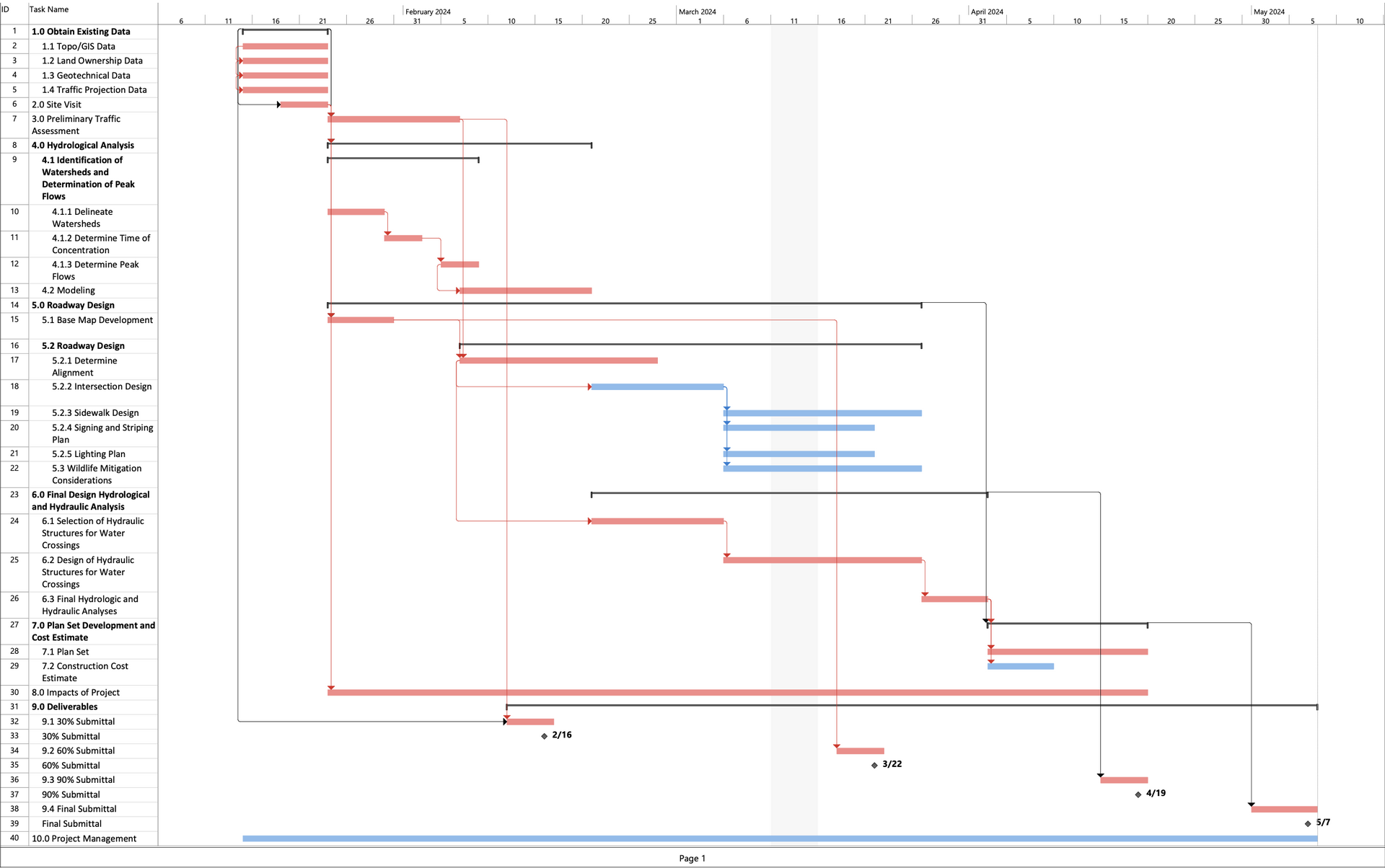
The following image is the project gantt chart. This outlines the project's current schedule.
This project is currently scheduled to begin on January 15, 2024 and complete on May 7, 2024.
This encompasses a total of 77 working days. Tasks in red define the project's critical path. These
are tasks which must be completed on time in order for the entire project to remain on schedule.

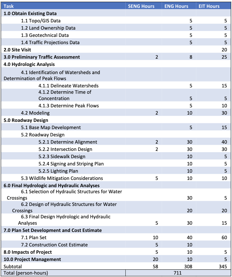
The table belows contains the projected staffing hours required for this project.
The hours are split between three positions, the senior engineer, engineer,
and engineer-in-training (EIT).

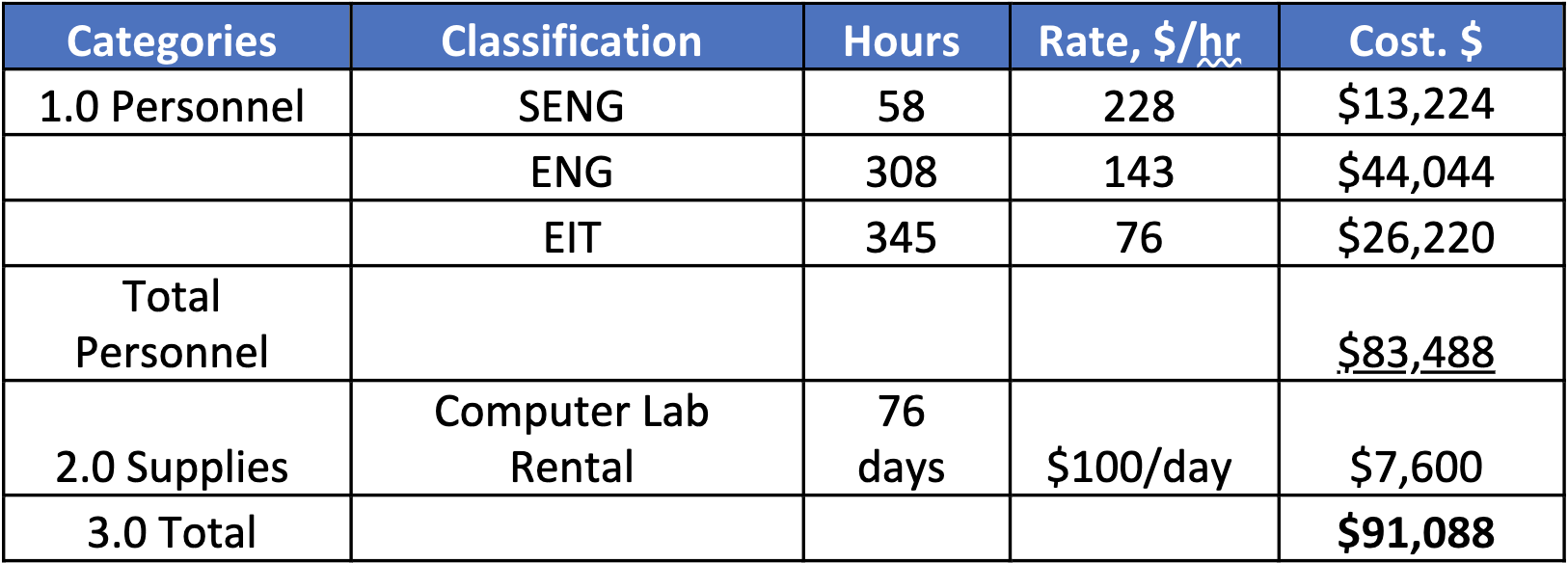
The table below contains the projected cost of engineering services for this project.
This includes personnel and supplies costs.

created with
Website Builder Software .