
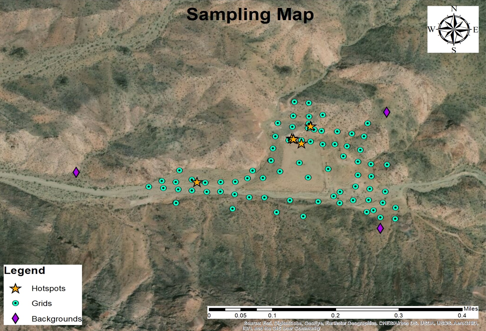
The The Tyro Mill site is located in Mohave County, AZ, approximately 15 miles from Bullhead City. The latitude and longitude of the site is 13° 13’ 29.68” N and 114° 27’ 32.33” W. The site is located off of a dirt road that is a popular destination for overnight camping and off-roading that can be accessed by car from AZ-Highway 68.


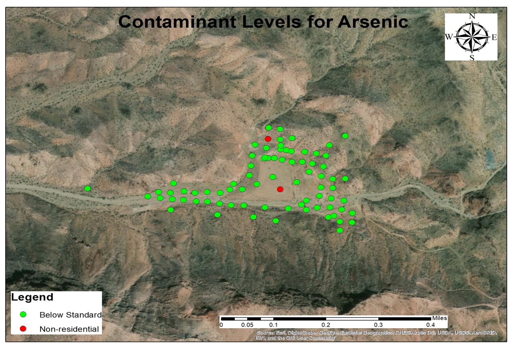
Each member of ACGM Engineering wore the proper personal protection equipment (PPE) as stated in the HASP within the Work Plan. Each member wore latex gloves, and proper clothing (long pants, hiking shoes, sunglasses, and hats); latex gloves were changed when taking each sample to lower the risk of cross contamination. Handheld GPS units were used to mark the location of each point. On the site the safety officer determined that the use of hazmat suits or dust masks would not be necessary. Once all points had been flagged, two teams were formed for the completion of the sampling and one member remained at the van to work sample control. Each sampling team noted the following information for each sample take: Sample Number, Time, GPS Coordinates, Soil Type, Appearance, Color, and Sampler.While in the field, a total of 5 hotspot samples and 3 background samples were collected, resulting in a total of 78 soil samples with aid from the TA. Hotspot samples were taken at locations where large amounts of tailings could be visibly seen and background samples were taken at locations that were in areas of similar soils, but undisturbed and sufficiently far from the site to not be impacted. The locations of the hotspots and background samples can be viewed on the map below.
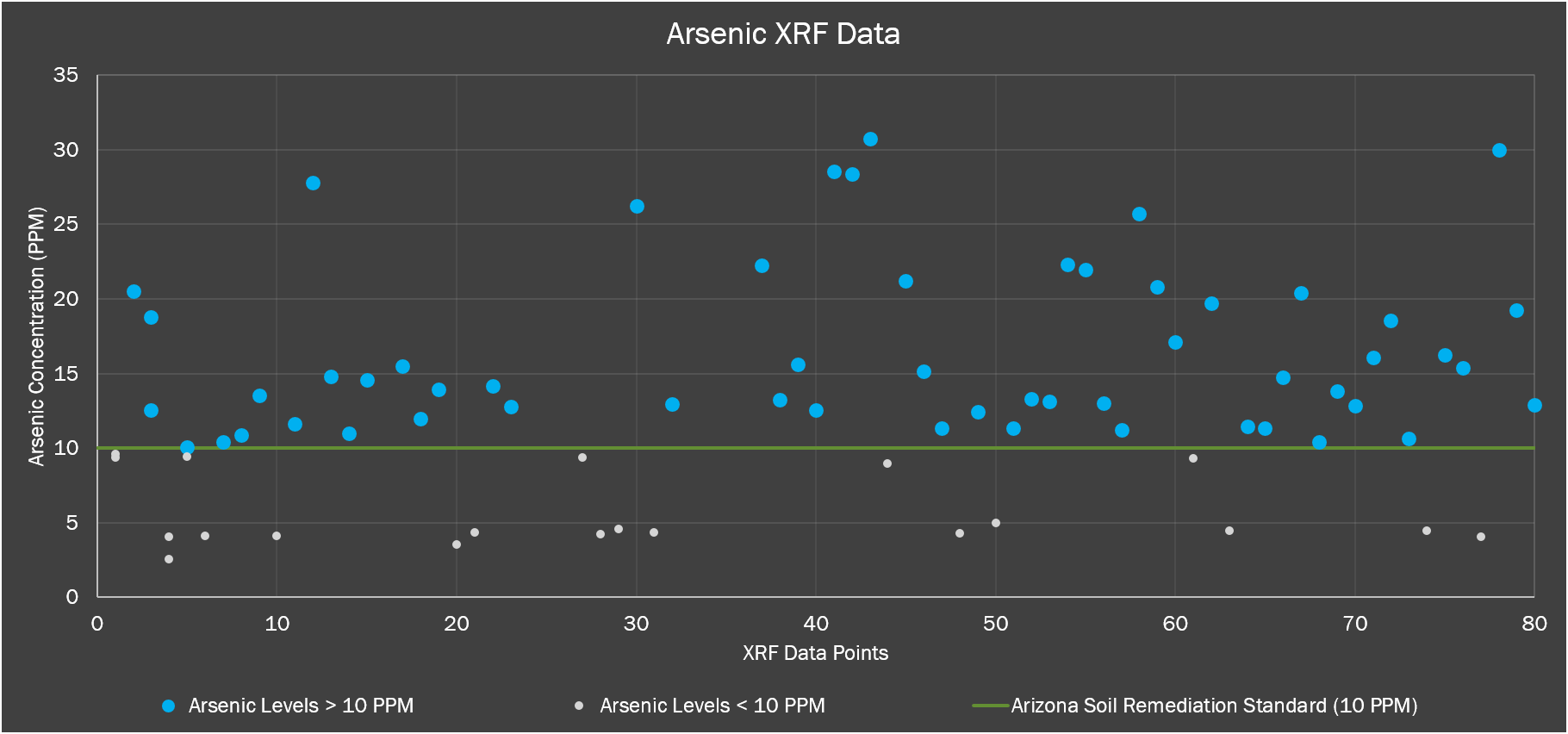
X-Ray Fluorescence (XRF) analysis was completed following EPA Method 6200: Field Portable X-Ray Fluorescence Spectrometry for the Determination of of Elemental Concentrations for Soil and Sediment. This method was developed to provide a preliminary identification of elements present in a soil sample to be used in conjunction with additional confirmatory testing. Based on the method, each sample that has passed through the No.40 sieve was be placed into a one gallon Ziploc bag and nine, approximately 1 gram, subsamples were taken using sample cups. The XRF analysis of the samples was completed in the Materials Lab within the Engineering Building at NAU.
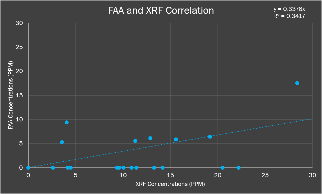
While determining the COCs for the human health and ecological risk assessments, the collected XRF data was corrected using a correlation of the XRF results along with data from FAA results of 20 samples sent to Western Technologies in Flagstaff, Arizona for further laboratory analysis. The 20 samples chosen represent a range of the XFR results obtained, from high to low concentrations.
Once the XRF data had been corrected using the correlation equation developed from the outside lab analysis, all COCs were confirmed and the 50% and 95% EPCs were determined, a human health risk assessment was developed. The corrected XRF data was also used in an Ecological Risk Assessment for several species- both endemic to the area and threatened or endangered- where the contamination found on site was compared to the Ecological Soil Screening Levels as developed by the EPA.
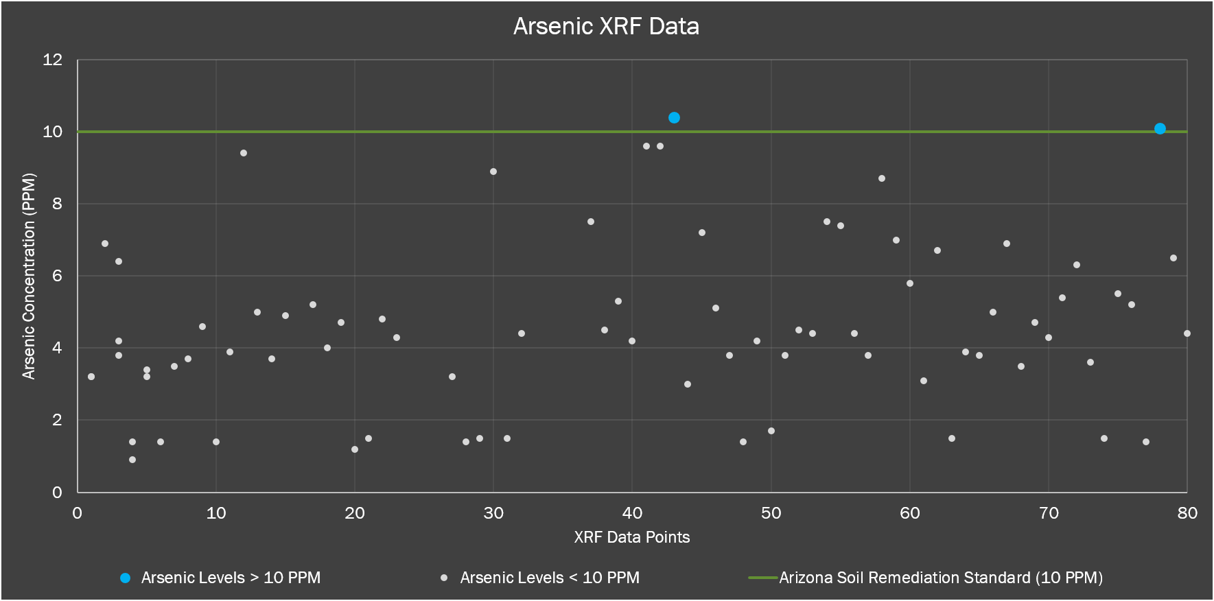
The sample located on top of the repository is TM_G43 and has a 10.4 ppm arsenic concentration which is slightly above the AZ Residential and Non-Residential standard of 10 ppm. Soil sample TM_G78 is located on the northern edge of the repository with an arsenic concentration of 10.1 ppm, which slightly exceeds the standards.
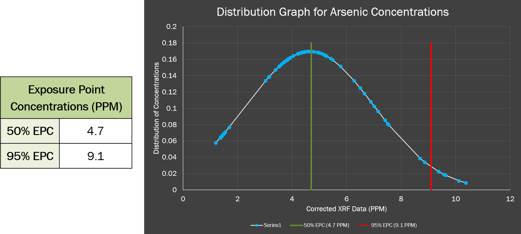
Using the normal distribution ACGM Engineering was able to determine the estimated permissible concentrations at a 50% and 95% confidence interval. The 50% EPC is the mean arsenic concentration and the 95% EPC is two standard deviations above the mean arsenic concentration. The EPC values can be viewed in Table shown.
The types of exposure that are analyzed for the human health risk assessment are as follows: ● Oral Ingestion of Soil ● Dermal Contact. One exposure scenario has been identified for this site: a recreational camper scenario using a time duration of 14 days. The 14 day time limit was determined by the state regulation that allows for a person to camp in one spot for a total duration of 14 days at a time. Residential and worker scenarios will not be considered because the site will never be developed for residential use and there is no need for a worker scenario since the site has already been remediated.
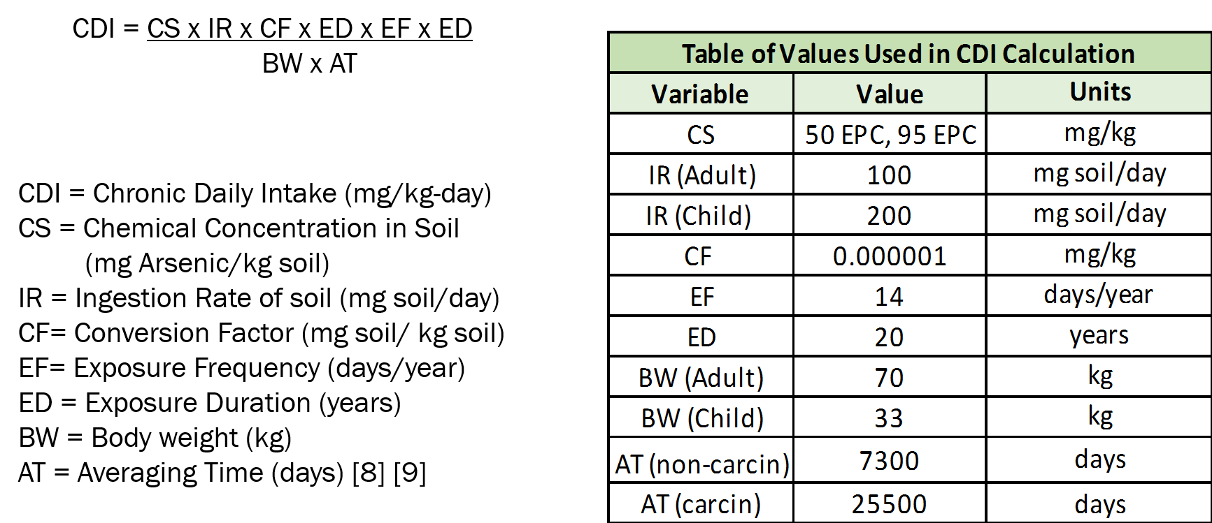
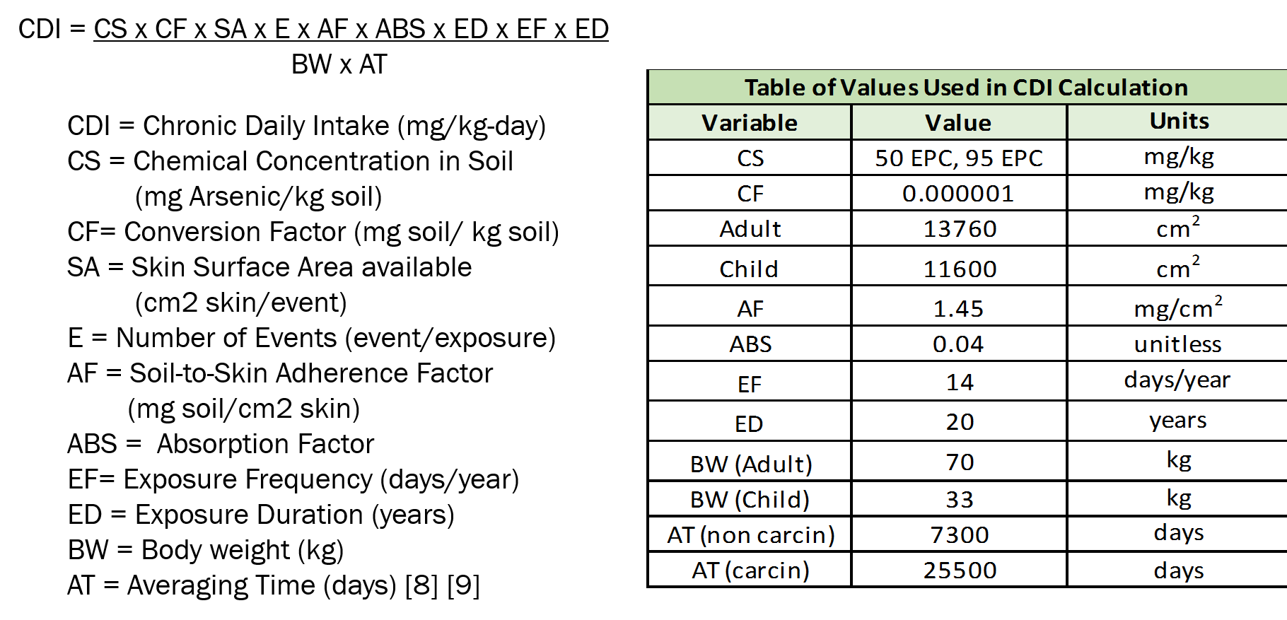
The exposure point concentrations for arsenic at 50 and 95 percent do not pose as a significant human health risk for dermal contact exposure. EPA standards indicate carcinogenic risk is present when exposure point concentrations is higher than one in a million and the non-carcinogenic risk is greater than 1.0. The Tyro Mill site is currently safe for locals to occupy the area for recreational activities.
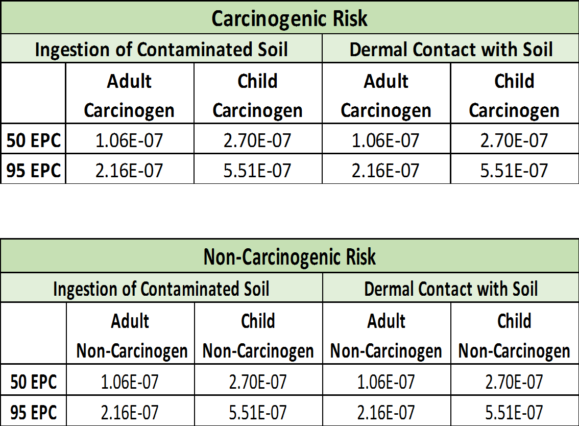
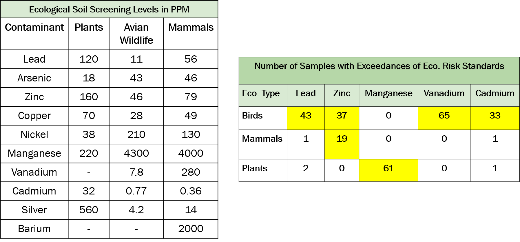
The ecological risk that is present for the birds, mammals and plants discussed above can be qualitatively determined using the information presented in the Tables below. The average lead concentration for the soil samples was 19 ppm, with the highest lead concentration recorded at 252 ppm for TM_G50 located on the northern edge of the repository. Lead contamination at the Tyro Mill site presents a risk to birds like the California Condor and the California Least Tern. Zinc had an average concentration of 60 ppm with the highest concentration reported at 151 ppm for TM_G78 located on top of the repository. Zinc at the site poses a threat to both birds and mammals found at the site. Manganese has a average concentration of 292 ppm with the highest concentration reporting at 459 ppm for TM_G9 located southeast of the repository. Manganese is a danger to plants like Desert Marigolds and several species of cacti at the site. Cadmium reported an average concentration of 33 ppm with the highest concentration of 57.6 ppm for TM_G55 located west of the repository. Field notes indicate grid sample 55 was near a fire pit. Vanadium reported an average concentrations of 10.8 ppm with the highest concentration at 622 ppm for TM_G57 located at the westend of the site. It is noted that the high concentration is not representative of the other soil samples collected on site. Vanadium and cadmium are a danger to birds found at the site. The ecological risk assessment above presents qualitative data analysis of which identified species may be at risk due to the contamination present at the Tyro Mill site.
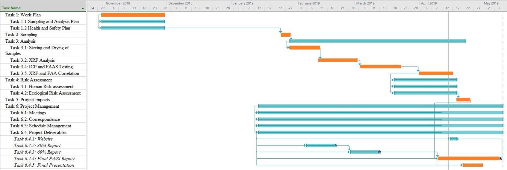
The Tyro Mill PA/SI project was originally planned to start at October 31st 2018 and set to finish on May 10th 2019 with a duration of 25 weeks. Along that time frame the tasks required to complete the project were set in order to meet the deadline of the project. Due to changes in NAU’s lab usage policy, ACGM team members could not access the NAU Materials Lab at the planned time which caused a delay of about a week to the project. The changes to the policy were made in order to insure the safety of the members accessing the lab. Tasks 3.1 and 3.2 were rescheduled to end at an earlier time, from Feb 6th 2019 for drying and sieving, and Feb 27th 2019 for XRF analysis to Feb 11th 2019 and Mar 1st 2019 on the modified Gantt chart. ACGM team members completed Tasks 3.1 and 3.2 in the new scheduled times. After the completion of Task 3.2, ACGM members determined that Task 3.3 Acid Digestion was no longer required per the guidance of the TA for the completion of the project. With the exclusion of Task 3.3 Acid Digestion ACGM members were able to make up the time that was lost in order to access the Materials Lab and continue progressing with the original times for the rest of the required tasks. The following ganttchart shows the final schedule of the project.
