Reference Reach Analysis
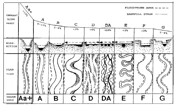
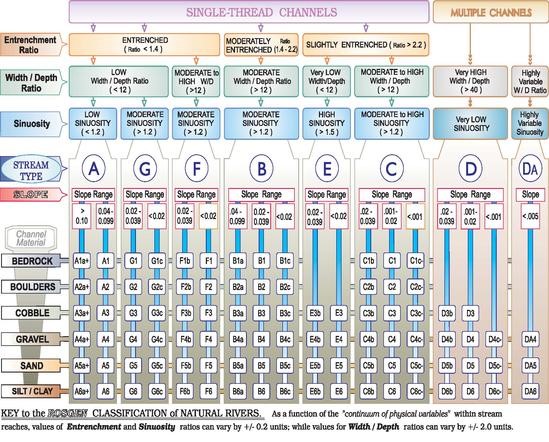
A section of channel in its natural state, also known as a reference reach, was identified upstream of the existing section of Schultz Creek adjacent to the ACE office. The reference reach analysis was conducted using the measurements obtained from the survey to determine the width to depth ratio, channel longitudinal and bank side slope and curvature. The Rosgen channel classification scheme was then used to classify the reference reach based on the width to depth ratio, sinuosity, and average slope. The classification aided in the determination of the channels natural parameters for design. A schematic diagram summarizing this channel classification system is shown below.
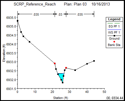
Based on the data obtained from the Rosgen classification, the reference reach was classified as an E3 channel. The overbank side slope was determined to be 0.109, which is about a 1:10 ratio. The average channel depth was determined to be 0.86 ft. The slope was determined to be 0.0153. From the data calculated, cross section 75 was utilized to obtain a design alternative channel design.
Due to the parameters found in the Rosgen classification, seen in Table 1 below, for cross section 75; the design alternative will be classified as an E channel. To increase stability, the channel will have a single trapezoidal entrenchment, rather than the single triangle cross section 75 contains. Cross section 75 had a bank full, the top of channel bank where water begins to overflow onto floodplain, width of 3.63 ft, which will be expanded to 5 ft. for the design alternative to allow for a greater flow. The base length of the trapezoid will be 3ft and the bank lengths will be 1ft on each side. The side slope of the entrenched trapezoid was determined to be 3:1 ratio. Also, cross section 75 had a depth of 0.5 ft, which will be kept the same for the design alternative. The side slope will be slightly lowered to ensure a ratio of 1:10 is met. In order to establish the surrounding floodplain, a ratio of about 5:1 will be used, where the overbanks will have a length of 15ft and a rise of 1.5ft. With a slope of 0.0153 and changing the bed lining to gravel for the design alternative, the channel is classified as E4.
Table 1: Rosgen Classification of Reference Reach
Reach |
Cross Section |
Width @ 2xBF Depth |
BF Width |
Depth |
Ave. Slope |
ER |
W/D |
Classification |
1 |
5 |
7.21 |
3.16 |
0.55 |
0.0055 |
2.28 |
5.75 |
E3 |
2 |
75 |
17.27 |
3.63 |
0.5 |
0.073 |
4.76 |
7.26 |
E3 |
3 |
115 |
9.64 |
4.79 |
0.49 |
0.0035 |
2.01 |
9.78 |
B2c |
4 |
145 |
11.84 |
6.31 |
0.28 |
0.01325 |
1.88 |
22.54 |
B2c |
5 |
200 |
5.82 |
2.78 |
0.33 |
0.0148 |
2.09 |
8.42 |
E3 |
6 |
240 |
14.06 |
6.38 |
0.42 |
0.0112 |
2.20 |
15.19 |
B2c |
As seen in Table 1 above, the second noticeable change in the reference reach was found at Cross Section 75. Noticeable changes in entrenchment and vegetation can be seen in Figure 6 shown below.

Figure 6 – Cross-section 75
The width to depth ratio has changed to 7.26, which is less than 12 making this channel agree with A, G and E classification. Based on the entrenchment ratio of 4.76, which is greater than 2.2, the channel is an E classification. Having a cobble bed lining, the classification if the channel is E3.
The fourth major change in the reference reach was found at Cross Section 145. A single triangular entrenchment can be seen in Figure 8 shown below.

Figure 8 – Cross-section 145
The entrenchment ratio was determined to be 1.88, which is greater than 1.4 and less than 2.2, leading to a B classification. An aspect that leads to the B classification is the slope that was calculated to be 0.01325, which is less than 0.02.The calculated width to depth ratio for cross section 145 is 22.54, which is greater than 12, verifying that it is within the range of the a B classification. Due to the boulder bedding of the channel, the classification obtains the number 2s making the channel a class B2c.
Reference Reach Characteristics
(EPA Webpage)

(Rosgen, 1994)
 Schultz Creek Restoration Project