Project Management
The project management section of this report describes the actions taken during the design and construction phases of the project to insure tasks were completed correctly and on time. Resources that assisted in project management included a project timeline, hours tracking document, meeting notes, and the required website. In addition to project management during the design and construction phases, a post monitoring phase is also required. The post monitoring phase of the project is discussed in detail in the following section.
Project Timeline
A timeline was constructed to plan and track the hours worked on the Schultz Creek Restoration Project. The timeline was a guideline for accomplishing tasks and was changed based on parameters to be met.
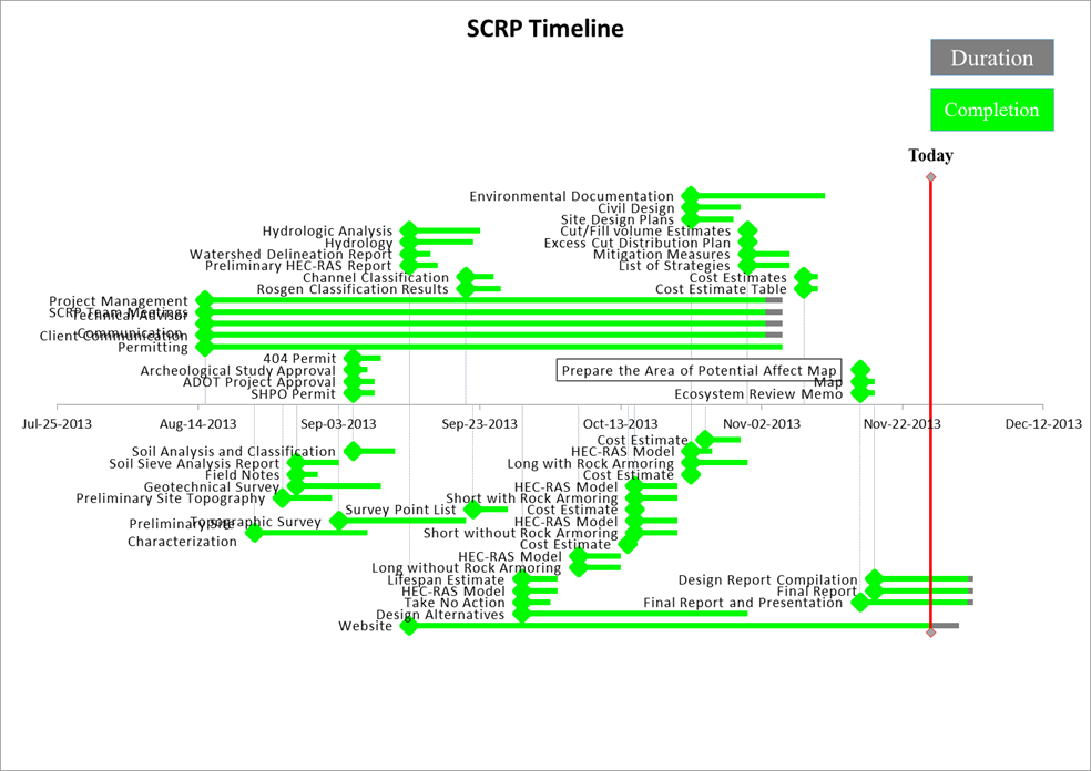
The timeline was constructed using Microsoft Excel. A Gantt chart was created using an XY scatter plot. The starting dates of each task were listed, along with the predicted amount of time necessary to complete each task. Once the start dates were uploaded onto the graph, error bars were used to create the allotted time for the task to be complete. A second error bar was created to show what percentage of the task was complete and how much more was needed to be complete. As time progressed, changes were made to the timeline to include new tasks and adjust the time predicted to accomplish the task. A third error bar was implemented on the graph to represent present time to notify what was accomplished, what needed to be finished and what to begin working on.
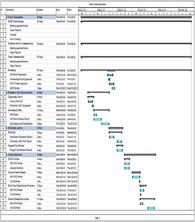
The finalized timeline had a few major adjustments to ensure the tasks were complete. The first major adjustment was to the topographic survey. The original start date was August 22, 2013, however due to some difficulties obtaining GPS surveying equipment; the actual surveying of the channel was prolonged from 4 days to 18 days. The GPS equipment acquired was calibrated in order to obtain correct data, which took a bit longer than anticipated. After the GPS was calibrated, a survey of the reference reach and existing channel was conducted. Unfortunately not all the data could be taken on the GPS survey and a Total Station was used in areas where thick tree coverage was an issue. Once all the data was obtained, the data was uploaded into AutoCAD Civil 3D, where discrepancies were found between the different surveying equipment because the GPS data was provided in Northing and Easting coordinate systems and the Total Station data was provided in latitude and longitude coordinate systems. The issues were finally resolved, but had taken a good portion of time, causing the timeline to be pushed back.
Another issue with the timeline was the parameters set for the design alternatives. Originally there were four design alternatives that all had different assets. However, as time progressed the team realized that there would be too many parameters to identify for all four design alternatives and decided to narrow the choices down to three major design aspects to have a total of five design alternatives. The new design alternatives were changed to take no action, a short rerouting with no rock armoring, a long rerouting with no rock armoring, a short rerouting with rock armoring and a long rerouting with rock armoring. Due to the addition of another design alternative, the time to complete the task was extended by another week to ensure the design criteria were met.
Another parameter that was added was the task of creating a website. The task was given such a large amount of time to accomplish because the website was continuously updated as tasks were accomplished. The task was associated with the final report and presentation because it will be used in the final presentation and will not be complete until the final report has been created. These tasks are not yet 100% because finishing touches need to be made after the practice final presentation is conducted on December 5, 2013. Unfortunately the final presentation is on December 6, 2013, which will give little time to adjust and correct any mistakes found.
Project Original Timeline

D.2: Revised Project Timeline

D.3: Task Completion Table
| Start Date |
Event | Duration | % Complete |
Completion |
| Nov-26-2013 | Today | 0 | 0% | 0 |
| Nov-26-2013 | Today | 0 | 0% | 0 |
| Aug-15-2013 | Project Management | 82 | 97% | 79.54 |
| Aug-15-2013 | SCRP Team Meetings | 82 | 97% | 79.54 |
| Aug-15-2013 | Technical Advisor Communication | 82 | 97% | 79.54 |
| Aug-15-2013 | Client Communication | 82 | 97% | 79.54 |
| Aug-15-2013 | Permitting | 82 | 100% | 82 |
| Sep-05-2013 | 404 Permit | 4 | 100% | 4 |
| Sep-05-2013 | Archeological Study Approval | 2 | 100% | 2 |
| Sep-05-2013 | ADOT Project Approval | 3 | 100% | 3 |
| Sep-05-2013 | SHPO Permit | 3 | 100% | 3 |
| Aug-22-2013 | Preliminary Site Characterization | 16 | 100% | 16 |
| Sep-03-2013 | Topographic Survey | 18 | 100% | 18 |
| Sep-22-2013 | Survey Point List | 5 | 100% | 5 |
| Aug-26-2013 | Preliminary Site Topography | 7 | 100% | 7 |
| Aug-28-2013 | Geotechnical Survey | 12 | 100% | 12 |
| Aug-28-2013 | Field Notes | 3 | 100% | 3 |
| Aug-28-2013 | Soil Sieve Analysis Report | 6 | 100% | 6 |
| Sep-05-2013 | Soil Analysis and Classification | 6 | 100% | 6 |
| Sep-13-2013 | Hydrologic Analysis | 10 | 100% | 10 |
| Sep-13-2013 | Hydrology | 9 | 100% | 9 |
| Sep-13-2013 | Watershed Delineation Report | 3 | 100% | 3 |
| Sep-13-2013 | Preliminary HEC-RAS Report | 4 | 100% | 4 |
| Sep-21-2013 | Channel Classification | 4 | 100% | 4 |
| Sep-21-2013 | Rosgen Classification Results | 5 | 100% | 5 |
| Sep-29-2013 | Design Alternatives | 32 | 100% | 32 |
| Sep-29-2013 | Take No Action | 4 | 100% | 4 |
| Sep-29-2013 | HEC-RAS Model | 5 | 100% | 5 |
| Sep-29-2013 | Lifespan Estimate | 5 | 100% | 5 |
| Oct-07-2013 | Long without Rock Armoring | 6 | 100% | 6 |
| Oct-07-2013 | HEC-RAS Model | 6 | 100% | 6 |
| Oct-14-2013 | Cost Estimate | 1 | 100% | 1 |
| Oct-15-2013 | Short without Rock Armoring | 6 | 100% | 6 |
| Oct-15-2013 | HEC-RAS Model | 6 | 100% | 6 |
| Oct-15-2013 | Cost Estimate | 1 | 100% | 1 |
| Oct-15-2013 | Short with Rock Armoring | 6 | 100% | 6 |
| Oct-15-2013 | HEC-RAS Model | 6 | 100% | 6 |
| Oct-23-2013 | Cost Estimate | 1 | 100% | 1 |
| Oct-23-2013 | Long with Rock Armoring | 8 | 100% | 8 |
| Oct-23-2013 | HEC-RAS Model | 3 | 100% | 3 |
| Oct-25-2013 | Cost Estimate | 5 | 100% | 5 |
| Oct-23-2013 | Environmental Documentation | 19 | 100% | 19 |
| Oct-23-2013 | Civil Design | 7 | 100% | 7 |
| Oct-23-2013 | Site Design Plans | 6 | 100% | 6 |
| Oct-31-2013 | Cut/Fill volume Estimates | 1 | 100% | 1 |
| Oct-31-2013 | Excess Cut Distribution Plan | 1 | 100% | 1 |
| Oct-31-2013 | Mitigation Measures | 6 | 100% | 6 |
| Oct-31-2013 | List of Strategies | 6 | 100% | 6 |
| Nov-08-2013 | Cost Estimates | 2 | 100% | 2 |
| Nov-08-2013 | Cost Estimate Table | 2 | 100% | 2 |
| Nov-16-2013 | Prepare the Area of Potential Affect Map | 1 | 100% | 1 |
| Nov-16-2013 | Map | 2 | 100% | 2 |
| Nov-16-2013 | Ecosystem Review Memo | 2 | 100% | 2 |
| Nov-16-2013 | Final Report and Presentation | 16 | 95% | 15.2 |
| Nov-18-2013 | Final Report | 14 | 95% | 13.3 |
| Nov-18-2013 | Design Report Compilation | 14 | 95% | 13.3 |
| Sep-13-2013 | Website | 78 | 95% | 74.1 |
Hours Tracking
|
Project Engineer |
||||
Task |
Sean Zimmerman |
Chris Janigo |
Mikey Sowadski |
Henry Ross |
Total |
Permitting |
16 |
5 |
5 |
5 |
31 |
Surveying |
22 |
32 |
12 |
29 |
95 |
Website |
2 |
18 |
2 |
2 |
24 |
Geotechnical Analysis |
10 |
6 |
8 |
10 |
34 |
Watershed Delineation |
6 |
2 |
4 |
2 |
14 |
Vegetation Analysis |
2 |
2 |
21 |
2 |
27 |
AutoCAD |
16 |
24 |
14 |
24 |
78 |
HEC-RAS |
2 |
2 |
14 |
2 |
20 |
Project Management |
4 |
10 |
4 |
4 |
22 |
Final Presentation |
5 |
5 |
5 |
8 |
23 |
Final Report |
24 |
18 |
12 |
18 |
72 |
Totals = |
109 |
124 |
101 |
106 |
440 |
Meeting Minutes
Meeting Date: August 27, 2013
Attendees: Chris Janigo, Henry Ross, Sean Zimmerman, Mikey Sowadski
Minutes: Research survey control points; Collect soil grab samples for sieve analysis
Difficulties: Establishing survey control; acquiring proper survey equipment
Current Tasks: Topographic survey; collecting site data
Meeting Date: September 5, 2013
Attendees: Chris Janigo, Henry Ross, Sean Zimmerman, Mikey Sowadski, Dr. Odem
Minutes: Contact MNA (Larry Stevens)?; Research permits: 404, SHPO, ADOT, ADEQ, Arch. Study?; Watershed delineation
Difficulties: Overgrown vegetation at site; acquiring GPS survey equipment
Current Tasks: Topographic survey; conducting geotechnical soil analysis on grab
Meeting Date: September 10, 2013
Attendees: Chris Janigo, Henry Ross, Sean Zimmerman, Mikey Sowadski, Dr. Odem
Minutes: Website research; 404 Permit Researched; geotechnical sieve analysis conducted
Difficulties: Troubleshooting TOPCON GPS equipment
Current Tasks: GPS Survey; permit research write ups; website development
Meeting Date: September 18, 2013
Attendees: Chris Janigo, Henry Ross, Sean Zimmerman, Mikey Sowadski
Minutes: Permit research; permit write ups for all permits completed; website under development
Difficulties: Uploading website to the server
Current Tasks: Reference reach survey; topo point data compilation; website development; watershed delineation
Meeting Date: September 24, 2013
Attendees: Chris Janigo, Henry Ross, Sean Zimmerman, Mikey Sowadski
Minutes: Total station reference reach survey completed; soil distribution curves produced, average soil particle sizes determined; site vegetative study is underway
Difficulties: Combining reference reach survey with GPS point data
Current Tasks: Watershed delineation; gather local weather/precipitation data; determine flood and average flows for hydraulic modeling; AutoCAD design alternative development; website development
Meeting Date: October 3, 2013
Attendees: Chris Janigo, Henry Ross, Sean Zimmerman, Mikey Sowadski
Minutes: Topography modeling is underway; website development still underway
Difficulties: Combining reference-reach survey with GPS point data
Current Tasks: AutoCAD design alternative development; website development; preliminary HEC-RAS model development; design alternative matrix
Meeting Date: October 17, 2013
Attendees: Chris Janigo, Henry Ross, Sean Zimmerman, Mikey Sowadski, Dr. Odem
Minutes: CAD designs are coming along; cut/fill estimates have been produced for first three designs; Floodplain roughness found to be approx. 0.035; Maximum channel velocity of 5 ft/s at 100 year flow
Difficulties: Exporting design alternatives from CAD to HEC-RAS; creating an optimized channel cross-section design; modeling design corridor in CAD
Current Tasks: CAD design alternative development; website development; HEC-RAS design alternative model development; Rosgen channel classification
Meeting Date: October 31, 2013
Attendees: Chris Janigo, Henry Ross, Sean Zimmerman, Mikey Sowadski, Dr. Odem
Minutes: Meeting scheduled with Matt Roberts from MNA – 4 main designs and a recommendation based on design decision matrix will be presented (Short design w/ rock structure recommended)
Difficulties: Creating refined and presentable plan sets for each design as well as the existing channel
Current Tasks: Choose final design an continue to refine it
Meeting Date: November 14, 2013
Attendees: Chris Janigo, Henry Ross, Sean Zimmerman, Mikey Sowadski, Dr. Odem
Minutes: (Brief advisor update); Final design has been selected and is being refined; final design report draft has been created
Difficulties: Rock structure sizing; cost analysis
Current Tasks: Rock structure sizing and cost analysis; commence all CAD and HEC-RAS design work; compile design report
Meeting Date: November 21, 2013
Attendees: Chris Janigo, Henry Ross, Sean Zimmerman, Mikey Sowadski
Minutes: Last formal group meeting, rapidly approaching end of semester deadlines; final tasks tabulated
Difficulties: Staying focused to meet all final deadlines
Current Tasks: continue adding to/editing design report, create appendices, update website, create final presentation
